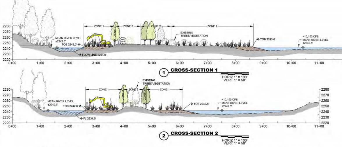
In-stream projects are part of our larger Snake River Stewardship Program (SRSP) designed to improve water quality in the Snake River. Specifically, these projects narrow and deepen sections of the Snake River channel far upstream of the Hells Canyon Complex (HCC) by expanding seasonal floodplains adjacent to river islands. This increases water velocity and reduces heating by decreasing the surface area of the river during low summer flows.
We plant these expanded floodplains with native trees and shrubs such as willows, rabbitbrush, currants, native grasses and sedges to prevent erosion, provide shade and improve wetland habitat.
Our second project was completed in the fall of 2021, and we anticipate many more over the coming decades.
An illustration of how this type of island project narrows the river channel is shown below.

Bayha Island
Bayha and Wright Islands are part of the U.S. Fish and Wildlife Service (USFWS) Snake River Islands Unit of the Deer Flat National Wildlife Refuge and are approximately 2.5 miles downstream of Walter’s Ferry in southwestern Idaho.
For this in-stream project, approximately 10 acres of floodplain were added adjacent to the islands. These videos show how the project began and what it looked like two years after completion:
Before:
After:
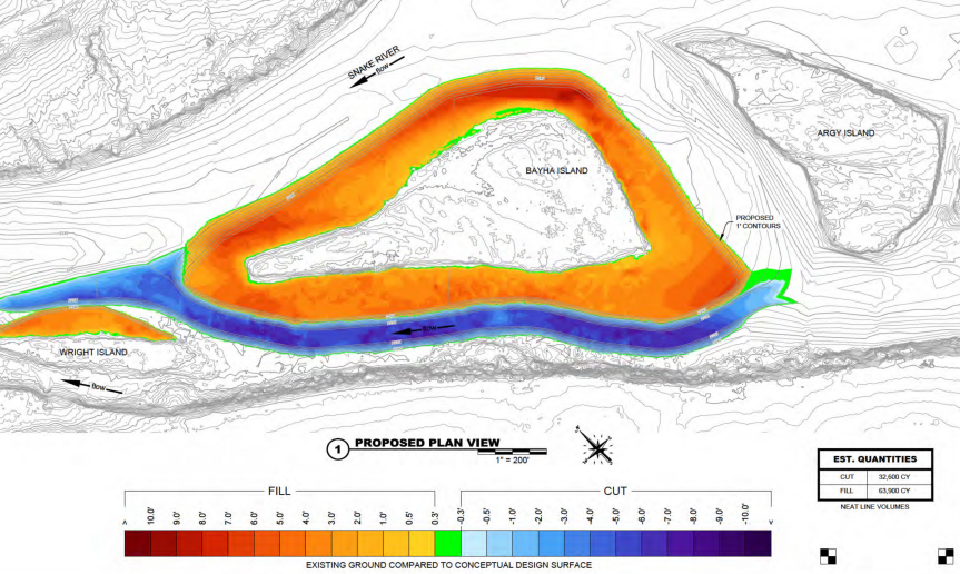
Construction consisted of dredging the river’s channel between Bayha and Wright islands and the south bank of the river, and narrowing the channel by creating additional wetlands around the islands. Construction was completed in 2016. Idaho Power and The Freshwater Trust continued to work on the island, additional plants and installing temporary seasonal irrigation to help the new plants become established.
In the illustration below, the orange and red indicate areas that were filled, while the blue is the river channel that was deepened. An estimated 80,000 cubic yards of fill material was dredged from the river bed or hauled from a gravel deposit on a neighboring landowner’s property. This kept approximately 4,000 dump truck trips off public roads and benefited the landowner by improving a field and pond.

Rippee Island
Idaho Power completed construction on the Rippee Island Research Project in fall 2021. The project created approximately 16.5 acres of floodplain, and the adjacent river channel was deepened to improve water flow and quality. This project builds on lessons learned from the Bayha Island Research Project. Rippee Island is located between the Walter’s Ferry and Bernard’s Ferry boat ramps (map).
For assistance with a PDF on this page or to request a PDF in an alternate format, please contact Customer Service at 208-388-2323 or 1-800-488-6151
